

Words & Photos by Robert Gibson


The trail for this installment is very near and dear to my heart (literally and metaphorically). However, it didn’t start out that way. The first time I rode this trail, 14 or so years ago, I was justifiably underwhelmed. Since then, I have ridden this thing well over 400 times, and this “boring” trail has taught me more than I ever thought possible.

TRAIL OF THE TAPE: LENGTH 3.5 MILES
ELEVATION GAIN: 339 FT
STARTING ELEVATION: 2,421 FT.
PEAK ELEVATION: 2,760FT.
The trail starts at the south end of the Catalina foothills, off Alvernon Way, about 200 yards north of River Rd., just across the street from the Binghampton Cemetery. There is also neighborhood access to the trail at a small dirt pull-out at the intersection of Alvernon Way and La Espalda. The trail concludes at a bridge (and rock garden) on Skyline Dr., right at the base of the Santa Catalina Mountains. At this point, one can either turn around and return the way you came or ride farther north and sample some of the punchy road climbs in the foothills.
Even though it's named the "Urban Assault Trail" or colloquially, "UAT," “assault” seems unwarranted, given the nature of the actual terrain. It’s a 3.5ish mile trail that meanders at a fairly consistent 2-3% grade, gaining around 340 feet of elevation as it parallels the Alvernon Wash. It’s a textbook “false flat.” It has a lot of what passes for dirt in Tucson (sand over hardpack with some embedded rocks). There are a handful of wash crossings and a couple of road crossings, so keep your head up and/or yield. It has enough corners to keep you honest and not be considered wholly “straight.” A good many of those corners are blind, and it is tremendously easy to cut someone else in half. Make sure to give a yell or ring a bell.
What makes the UAT special is how convenient and versatile it is. If you make it a workout, it’s a great steady-state interval, offering 15-20 minutes of consistent effort. If you are looking for 30 minutes of easy pedaling, it makes a great recovery ride. Looking for a place to take your kids or someone new to mountain biking? Only have an hour or so for a ride? It’s a trail that can be ridden in early Summer mornings, Spring and Fall lunch hours, or in the waning light of winter afternoons. If you need a longer ride, you can do repeats on it. Four times up and down, with some additional foothills work, will give you 40 plus mile ride with almost 2,800 feet of climbing.
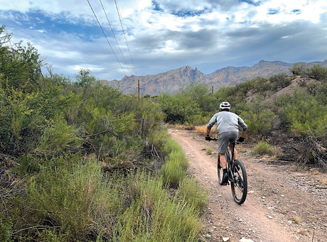
It makes a great lab environment as well. Did you fit some fancy parts or want to test out/confirm some adjustments? The UAT offers a fairly controlled setting that facilitates repeated testing at varied efforts, without the potential to ruin an “actual ride” ride. The UAT can easily be all of these... It’s a trail that can wear many helmets.
While this trail does have dirt and plenty of rocks, its lack of prominent features means one can ride a number of bicycles on this trail. I’d classify it as a rockier
gravel ride or a smoother mountain bike ride. It’s tame enough for a gravel bike, but a single-speed or short-travel mountain bike are very much at home.
The UAT cuts through several residential areas. Due to ranch and horse property laws that were established decades ago, when you ride this trail, there will be times when you will either be skirting or riding through someone else’s private property. Trail etiquette and courtesy should be overtly and abundantly exercised, especially if you are descending the UAT. It is very easy to get up to and carry a lot of speed. It’s also very easy to encounter someone and invite a collision at one of those aforementioned blind corners. So, keep your speed in check, your gratitude large, your numb
